
Open User Map
Turn your WordPress site into a collaborative map where visitors add locations, and you approve updates.
Visit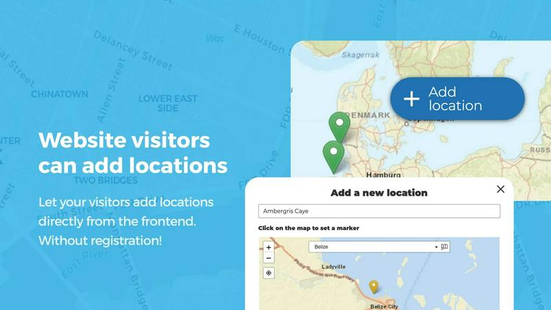
About Open User Map
Open User Map is a powerful, interactive maps plugin for WordPress that transforms how you and your website visitors engage with location-based data. Unlike traditional map solutions that require complex coding, expensive Google Maps API keys, or lengthy setup processes, Open User Map offers a streamlined, user-friendly approach to creating collaborative maps. The core value proposition is simple: enable your visitors to contribute locations directly to your map through frontend submissions, while you maintain full control through customizable approval workflows. This plugin is designed for website owners, community managers, business owners, and organizations who want to crowdsource location data without technical headaches. With over 15,000 active installs and a perfect 100% five-star rating, Open User Map has become the number two map plugin on WordPress.org by solving a fundamental problem: making map creation and community contribution accessible to everyone. The plugin eliminates all barriers to entry, requiring no coding skills, no API key management, and no complex configuration. You get a fully functional, interactive map that your visitors can add to, edit, and explore. Whether you are building a local business directory, a community events map, a travel guide, or a campus resource locator, Open User Map provides the tools you need to create an engaging, up-to-date, and user-driven mapping experience. The plugin also offers a premium PRO version with advanced features like custom image maps, advanced filtering, lines and areas, upvotes and ratings, and more, all available through a risk-free seven-day trial.
Features of Open User Map
Frontend Location Submissions and Editing
Allow your website visitors to add and edit locations directly on your map without needing any backend access. When a user clicks the Add location button, they can place a marker on the map and submit details such as name, description, and custom fields. All submissions are held for your approval before going live, ensuring quality control. Additionally, users can edit their own existing locations, keeping the map data accurate and current without burdening your administrative team. This feature turns your map into a living, community-driven resource.
Categorization and Filtering of Markers
Organize your map markers into distinct categories, each with its own unique icon for instant visual recognition. This feature allows you to group locations by type, such as restaurants, parks, events, or services, making the map easy to scan. Visitors can then filter the map to show only the categories they are interested in, improving usability and reducing clutter. Each location can also belong to multiple categories, ensuring that a single point of interest can be represented in all relevant groupings, such as a park that is also an event venue.
Lines and Areas for Routes and Regions
Go beyond simple point markers by adding lines, paths, zones, and polygons to your map. This feature is ideal for highlighting hiking trails, bus routes, service areas, event grounds, neighborhoods, or construction zones. Distances and area sizes are calculated automatically, providing helpful measurements directly on the map. You can create custom shapes that help visitors understand spatial relationships at a glance, making your map far more informative than a collection of pins.
Custom Image as Map
Upload any image and transform it into a fully interactive map, eliminating the need for a traditional geographic map. This powerful feature works perfectly for floor plans, event layouts, game maps, product diagrams, campus guides, or seating charts. Visitors can place markers directly on the image with the same functionality as a standard map, including adding locations, displaying custom fields, and enabling filtering. This opens up entirely new use cases for interactive mapping beyond geographical locations.
Advanced Filter Interface
Create a dedicated filter sidebar that appears next to your map, allowing visitors to narrow down locations based on any custom field you have configured. You can add custom HTML content sections to display additional information, branding, or instructions. This feature provides a more intuitive and powerful way for users to explore your mapped data, especially when dealing with large datasets or complex categorization schemes.
Upvotes, Likes, and Star Ratings
Enable community engagement by allowing visitors to upvote or like locations, helping to highlight the best places or flag inappropriate content. For more granular feedback, you can also enable a full one-to-five star rating system. These features are perfect for community-driven maps where user input helps surface the most valuable or popular locations automatically.
Use Cases of Open User Map
Community-Driven Local Business Directory
Create a comprehensive directory of local businesses where owners and customers can add new listings and update existing information. For example, a city tourism board can let restaurant owners add their locations, hours, and menus, while visitors can rate and review them. The approval workflow ensures only verified businesses appear, and the filtering system allows users to search by cuisine type, price range, or neighborhood. This creates an always-current, user-maintained resource that boosts local commerce.
Interactive Campus or Park Guide
Build an interactive map for a university campus, large office park, or public garden where users can add points of interest like buildings, restrooms, parking lots, and landmarks. Students can mark study spots, event locations, or construction zones. The lines and areas feature can highlight walking paths or restricted zones. With the custom image map feature, you can even use a campus blueprint or aerial photo as the base layer, creating a highly intuitive navigation tool for newcomers.
Event and Festival Mapping
Manage complex event grounds by allowing vendors, organizers, and attendees to add their locations to a shared map. Food trucks can mark their spots, stages can be highlighted, and restrooms or first aid stations can be pinned. The upvote and rating features let attendees rate food vendors or suggest the best viewing spots. The advanced filter interface helps visitors find exactly what they need, such as vegetarian food options or quiet seating areas, all in real time.
Crowdsourced Travel and Adventure Guide
Launch a travel website where users contribute their favorite hiking trails, scenic viewpoints, hidden cafes, or camping spots. Each location can include custom fields for difficulty level, best season to visit, or gear recommendations. The lines and areas feature allows users to draw actual trail routes or highlight wildlife zones. The star rating system helps surface the most popular destinations, while the approval workflow prevents spam. This creates a dynamic, ever-growing guide driven by a passionate community.
Frequently Asked Questions
Do I need a Google Maps API key to use Open User Map?
No, you do not need a Google Maps API key. Open User Map works out of the box without any external API keys or complex setup. This eliminates a major barrier to entry, saving you time and money while avoiding the technical headaches of managing API credentials and usage limits.
Can visitors add and edit locations without logging in?
Yes, you have full control over user permissions. You can allow visitors to add and edit locations without requiring a login, or you can restrict submissions to registered users only. This flexibility lets you balance ease of contribution with spam prevention based on your specific needs.
How does the approval workflow work?
When a visitor submits a new location or edits an existing one, the submission is held in a pending state. You receive a notification and can review the submission from your WordPress admin panel. You can then approve, reject, or edit the submission before it goes live on the map. This ensures all content meets your quality standards.
Can I use a custom image like a floor plan instead of a geographic map?
Yes, the Custom Image as Map feature allows you to upload any image and turn it into a fully interactive map. This is perfect for floor plans, event layouts, seating charts, game maps, or any other non-geographic visual. Visitors can place markers on the image with the same functionality as a traditional map.
Is there a free version of Open User Map?
Yes, a free version of Open User Map is available for download on WordPress.org. It includes core features like frontend submissions, approval workflows, and categorization. The PRO version adds advanced features like custom image maps, lines and areas, advanced filtering, upvotes, ratings, and opening hours.
Pricing of Open User Map
Open User Map offers a free version available on WordPress.org. The PRO version can be tried free for seven days with no credit card required and no automatic conversion to a paid subscription. For specific pricing details on the PRO version, please visit the official Open User Map website.
Similar to Open User Map

Unifyca centralizes client website documentation, credentials, maintenance, and backups so your agency controls everything from one platform.

Shadcn Examples offers ready-to-use React and Tailwind UI kits for building diverse web applications effortlessly.

Webleadr helps you effortlessly find and contact web design leads and businesses without websites in just a few clicks from anywhere.

Idearium crafts impactful websites and digital strategies that drive growth and elevate your brand's online presence.

Effortlessly host and share any file with a simple drag and drop, generating shareable links in seconds.

CrawlKit is an API-first platform that simplifies web scraping, enabling developers to extract structured data.

Easily compare and select top SaaS boilerplates to streamline your app development and accelerate your project launch.

Accelerate your development with the Shadcn UI Kit's ready-made components, templates, and admin dashboards.